CAMBODIA NATIONAL
LEVEL 1 SURVEY

7.2 Use of Topographic Maps, Satellite Images and GPS

Four major sources of geographic information were used by the survey. Three of these sets of information are available locally in Phnom Penh and the fourth can be ordered through the local dealer of satellite imagery. This section discusses the details of each set of information and how its was used in the survey. The information sets are:

  1. Topographic maps at 1:50,000
  2. Topographic maps at 1:100,000
  3. Satellite images Landsat 7™ Thematic Mapper
  4. Administrative boundaries and village points from the Department of Geography

1. Topographic maps at 1:50,000:

The only complete map coverage of Cambodia is the 1960's topographic maps. These maps were prepared under the direction of the Department of Defense and published by the U.S. Army Topographic Command, Washington D.C. It is widely acknowledged to be out of date as there have been many changes to roads, settlements and land cover in the last 40 years. This map set is comprised of 295 individual map sheets and was obtained from the U.S. Embassy in Phnom Penh. Specifications are:

Scale 1:50,000
Spheroid Everest
Grid 1,000 meter UTM Zone 48
Vertical Datum Mean Sea Level at Ha Tien
Horizontal Datum    Indian Datum 1960

All individual map sheets were scanned and geo-referenced utilizing MAPSCAN software available without charge at the ESRI web site. Four or more points were used in the registration process.

2. Topographic maps at 1:100,000:

A new partial coverage map set was produced just before the survey began by JICA (Japanese International Cooperation Agency) assistance to the Ministry of Public Works and Transport. These 41 map sheets cover the central area of Cambodia, in which most of the population live, and the more densely populated areas to the northwest around the Tonle Sap lake. They were prepared from SPOT images obtained between November 1996 and March 1997. This map set is available from The Ministry of Public Woks and Transport. Specifications are:

Scale 1:100,000
Spheroid Everest
Grid 1,000 meter UTM Zone 48
Vertical Datum Mean Sea Level at Ha Tien
Horizontal Datum    Indian Datum 1960

A second phase of the JICA mapping is currently underway and will produce new maps at the same scale for the remainder of the country over the next two years.

3. Satellite Image Scenes:

To guide the survey in the remaining areas of the country not yet covered by the JICA mapping, the survey purchased Landsat 7™ scenes. Each scene had to be geo-referenced and rectified before it could be used in place of a map. This referencing and rectification was done for the survey by the Department of Wildlife and Forestry. The satellite images were made available to the department in a cooperative arrangement in return for geo-referencing the images. This saved the survey having to rectify the images using image analysis software. Due to extensive cloud cover during the rainy season all image products were obtained during the dry season. In the rainy season, widespread flooding in many parts of the country reduced the usefulness of these images as mapping and navigation tools.

For example, in Battambang Province the 1:50,000 topographic maps do not show a new road through an area that was forested when the map was produced in the 1960's. The Landsat 7™ image for this area clearly shows the new road. When the suspected areas, village points, and benchmarks for each suspected area are plotted on the satellite image, they are all clearly related to this new road. The following illustrations show these survey results plotted first on the old topographic maps, and secondly on the satellite image.

Click here to view the Topographic Map
Click here to view the Satellite Image

4. Administrative boundaries and village points:

Provincial, district and commune boundaries were obtained from the Department of Geography, Council of Ministers. In addition the department was able to provide digital files of center points for all administrative areas, including villages as well as river and road files digitized from the 1:50,000 scale U.S maps. However there are no boundary files for villages, as the exact boundaries have never yet been defined and documented.

Battambang Province

Team two received orders to conduct the survey in villages neighbouring the Thai-Cambodian border located in Phnom Preak district in November 2001. After they had completed the survey, their data was sent to Phnom Penh to be entered in the database. As part of the data entry process the location of all points with coordinates is plotted on maps and checked for accuracy. While checking the village point of one of the villages in Phnom Preak District it was noticed that according to the map it was on the wrong side of the Thai border. As a result of this, the Database Unit returned the survey data back to Team Two for checking. The team leader returned to this district to verify the error, but after the team leader had checked the map he realised that the village point was correct, but the map was hopelessly incorrect with no connection to reality. These maps were made and published in the 1960s. We also had similar experiences happen along the Cambodian-Vietnamese border.

(By: Mao Vanna)

As the survey progressed it became evident that many of the center points and boundaries had been changed by historical events and practical concerns on the ground, or had been inaccurately recorded. Each province, district and commune administration was able to tell us which village comprised each commune and so on.

In addition the survey produced a village center point (usually the house of the village chief) and a landmark GPS reading. As a result we were able to correct boundary and village point files to ensure that the administrative hierarchy is correctly shown on all survey maps. These modified files are a survey tool and by no means are considered to be official.

Administrative Unit     Number of Units     Boundaries Amended     Center Points amended    
Province 24 18 -
District 186 131 -
Commune 1629 881 -
Village 13910 - 12913

Uses of Maps

The USA produced 1:50,000 maps were the basic maps used by the survey. However without GPS the maps would have been inadequate for locating villages and access roads. Using the JICA maps and the satellite image scenes enabled field crews to navigate efficiently in areas where the basic maps were particularly out-dated. In detail, maps were used for:

1. Field navigation for survey detachments, team leaders, field management and QA/QC management.

Koh Kong

There is no road through Koh Kong Province, which is mountainous along the Thai border. In the absence of any useful maps we had to get guidance and directions from the Commune leaders and sometimes these directions were not clear. Our motorcycles often had to be pushed through muddy fields and jungles. We lost our way several times in the dense forest and once we were lost in the forest for the whole day. During the day we were eating wild fruits, serving as our meals. When we reached the village we asked the village chief to accompany us to view a suspected area. To make it easier for him we offered him a ride on the motorcycle and he was happy to accept. We made him put on a helmet as this is a standard safety procedure in the SOPs. When we arrived near the suspected area we stopped got off the bikes and removed our helmets. The chief said to me that he had no idea where was the suspected area and he was totally lost. We figured out that with the helmet on he had not been able to follow the landmarks along the trail. So we had to return to the village and start all over again without the helmet on. Then he was able to show me everything. In this village, even the native villagers and those villagers who worked as guides lost their way sometimes.

(By: Pork Pry, DT8)

2. Planning of field survey including time required to travel, deployment of detachments, best locations for accommodation and field HQ, and motorcycle repair bases.

3. The Database Unit used a combination of the maps and images to produce district and commune scale field maps which the field survey unit used for planning, recording information, village and suspected area sketch mapping and navigation purposes.

Otdor Mean Chey Province

Banteay Ampil district, Chup Koki Commune: In Chup koki khang it is very difficult to compare our maps to the actual landscape as there have been so many changes. Also the villages are very close to the Thai border and we were afraid to be caught crossing the border without permission and the proper papers. We had to stop frequently to ask anyone around where we were and to make sure that we had not entered Thailand.

(By Prak Nhort, DT7)

4. QA/AC at the Database Unit included a comparison of all area and village sketches, village center points and landmarks and finally suspected area benchmarks against information on the most suitable map or image.

5. Map products produced by the survey showing location of villages and suspected areas are available based on any of the four map products.

As all field survey personnel were equipped with GPS it was possible to overcome the extraordinary deficiencies in the available maps. With few exceptions this assumption proved correct, see section 10.4 - Surveyor Stories.

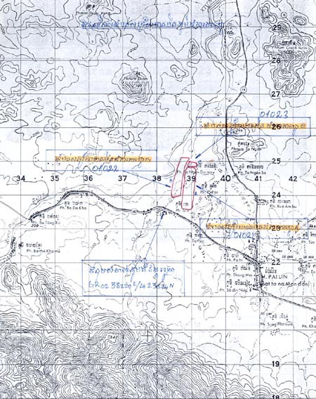
surveyors drew suspected areas (in red) and indicated
GPS coordinates (in yellow) on photocopies of base maps.

Next Section - 7.3 Cambodia Mine Victim Information System
Back to Table of Contents